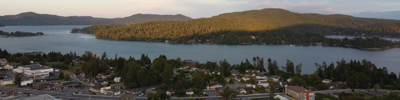
Picture Sooke: The Final Frame – Completing our Official Community Plan
Sooke is moving forward with finalizing its Official Community Plan (OCP), which will guide how Sooke grows and develops over the next 20 years.
About this project
Sooke is advancing its Official Community Plan (OCP) toward completion, building on the extensive work completed between 2020 and 2023. The project, which had been on pause since 2023, is resuming to incorporate previous community feedback and align with new provincial requirements under Bill 44: Housing Statutes (Residential Development) Amendment Act, 2023.
Our goal is to deliver an OCP that reflects the values and priorities of our community – helping us make informedContinue reading
Sooke is moving forward with finalizing its Official Community Plan (OCP), which will guide how Sooke grows and develops over the next 20 years.
About this project
Sooke is advancing its Official Community Plan (OCP) toward completion, building on the extensive work completed between 2020 and 2023. The project, which had been on pause since 2023, is resuming to incorporate previous community feedback and align with new provincial requirements under Bill 44: Housing Statutes (Residential Development) Amendment Act, 2023.
Our goal is to deliver an OCP that reflects the values and priorities of our community – helping us make informed decisions that shape the future of Sooke in a way we can all envision together.
What is an OCP, and why is it important?
An Official Community Plan is a key document that guides and manages land use decisions within the District. The authority to establish an OCP is set out in the Local Government Act.
An OCP outlines a long-term vision for the community and provides policy direction on the fundamental elements that shape it, such as land use, transportation, housing, the environment, infrastructure, parks, agriculture, economic development, arts and culture, and climate action. It serves as an overarching framework that is implemented through the District’s plans, policies, and bylaws.
Developing an OCP is a collaborative community effort. It reflects the community’s collective vision for future growth and development. Community members, local committees, and other stakeholders help shape the OCP through meaningful and inclusive engagement.
Once adopted by Council, the OCP becomes an official bylaw that informs future decisions made by Council and staff. More information about our current OCP (adopted in 2010) can be found here.
Where this project began (2020-2022)
Work on the OCP began in 2020 and made significant progress through to 2022. More than 2,000 residents, youth, businesses, and First Nations partners were engaged to help establish a shared community vision and develop the draft OCP. This draft was presented at a Public Hearing in September 2022. In 2023 the process was paused.
This pause provided an opportunity to:
- Review additional community feedback on the draft OCP
- Consider new provincial housing legislation (Bill 44)
- Refresh the draft with updated data and clearer language
More information about past engagement and earlier phases of the project can be found here.
Where we are now (2023-present)
In 2023, the Province introduced new housing legislation (Bill 44) requiring communities like Sooke to update their Official Community Plans by the end of 2025. These updates must include land use policies that respond to housing needs identified in the District’s Housing Needs Report (updated in 2024).
At its January 27, 2025 meeting, Council directed staff to proceed with completing the OCP. Since then, staff have reviewed the 2022 draft and presented preliminary updates at the July 14, 2025 Regular Council Meeting. These refinements reflect community feedback received throughout 2022 and 2023.
The District will soon be inviting the community to review the revised draft and share their input as we move toward finalizing the OCP.
-
Official Community Plan Bylaw No. 800, 2022 (November 2025) – Public Hearing Summary and Next Steps
Share Official Community Plan Bylaw No. 800, 2022 (November 2025) – Public Hearing Summary and Next Steps on Facebook Share Official Community Plan Bylaw No. 800, 2022 (November 2025) – Public Hearing Summary and Next Steps on X (formerly Twitter) Share Official Community Plan Bylaw No. 800, 2022 (November 2025) – Public Hearing Summary and Next Steps on Linkedin Email Official Community Plan Bylaw No. 800, 2022 (November 2025) – Public Hearing Summary and Next Steps linkThe District of Sooke has completed the Public Hearing for Official Community Plan (OCP) Bylaw No. 800, 2022 (November 2025) and has compiled all public input received to date. The bylaw is now before Council for consideration of Third Reading and Adoption as indicated in the related staff report.
What We Heard
Between October 22 and December 3, 2025, the District received input through written submissions and verbal comments at the Public Hearing. In total, 146 written submissions and 62 speakers participated. Feedback reflected a wide range of views, including both strong support for the updated OCP and concerns focusedContinue reading
The District of Sooke has completed the Public Hearing for Official Community Plan (OCP) Bylaw No. 800, 2022 (November 2025) and has compiled all public input received to date. The bylaw is now before Council for consideration of Third Reading and Adoption as indicated in the related staff report.
What We Heard
Between October 22 and December 3, 2025, the District received input through written submissions and verbal comments at the Public Hearing. In total, 146 written submissions and 62 speakers participated. Feedback reflected a wide range of views, including both strong support for the updated OCP and concerns focused on environmental regulation, waterfront policies, growth, and infrastructure.
Key themes included:
Support for the OCP
Several submissions described the updated OCP as a balanced, forward-looking plan integrating housing, climate action, environmental protection, and growth management. Supporters emphasized the need to modernize the 2010 OCP and urged Council to adopt the bylaw and refine elements as needed over time.
Foreshore & Environmental Development Permit Areas (DPAs)
Concerns centred around:
- The 15-metre foreshore buffer, described by some as unclear or too restrictive.
- Potential impacts on property values, rebuild rights, and the cost of professional reports.
- Overlapping environmental DPAs and a desire for more site-specific mapping.
Others supported stronger environmental protection, with some calling for larger buffers.
Process, Notification & Engagement
Some residents, particularly waterfront owners, felt engagement and notification could have been more direct. Others noted that the OCP process has spanned multiple years with extensive opportunities for input.
Transportation, Parks & Trails Planning
Submissions sought clarification on how the OCP aligns with the Transportation Master Plan and Parks and Trails Master Plan. Several residents expressed concern about conceptual shoreline access or trail routes shown near private properties, emphasizing the need for clear communication that these are long-term concepts, not commitments.
Property Rights & Constructive Taking Concerns
A number of submissions referenced the Annapolis v. Halifax decision and questioned whether environmental DPAs could limit reasonable use of private property. Staff clarify that:
- DPAs regulate how development occurs, not whether land may be used.
- The OCP does not grant public access to private property, change zoning, or remove permitted uses.
Indigenous Acknowledgement Language
Some residents questioned references to “unceded territory,” while others supported keeping reconciliation-oriented language. Staff confirmed that acknowledgements are non-regulatory and do not affect land title or private property rights.
Growth, Housing & Infrastructure
Residents raised concerns about:
- Density and growth targets.
- Highway 14 congestion and servicing capacity.
- Potential taxation or financial implications.
Others supported the compact growth strategy and alignment with provincial housing legislation.
Staff Response
After reviewing all written and verbal input, staff advise that:
- No substantive amendments are recommended at this time - please see the staff report for fulsome responses on input and clarifying information.
- Issues raised do not require changes that would alter permitted uses, densities, or activities in a manner that would trigger a new Public Hearing under the Local Government Act.
- The OCP’s environmental, growth, and policy frameworks are consistent with best practice across B.C. and legally defensible.
- Engagement requirements have been fully met, and the Public Hearing provided a complete and transparent record for Council consideration.
Next Steps
With the Public Hearing complete, Council will consider Third Reading and potentially Adoption of OCP Bylaw No. 800, 2022 (November 2025) on Monday, December 8, 2025
If adopted:
The OCP takes effect immediately, and staff will proceed with:
- Guidance for applicants, including information on DPA triggers and exemptions.
- Public-facing materials, including FAQs and homeowner bulletins.
- Updates to application forms, checklists, and technical guidance.
- Bringing forward required amendments to the Fees and Charges Bylaw and Development Procedures Bylaw in early 2026.
- Notifying development professionals, agencies, and partner governments of the transition.
-
Public Hearing Scheduled for December 3 at 6:00 p.m.
Share Public Hearing Scheduled for December 3 at 6:00 p.m. on Facebook Share Public Hearing Scheduled for December 3 at 6:00 p.m. on X (formerly Twitter) Share Public Hearing Scheduled for December 3 at 6:00 p.m. on Linkedin Email Public Hearing Scheduled for December 3 at 6:00 p.m. linkThe District of Sooke will hold a Public Hearing on Wednesday, December 3, 2025, at 6:00 p.m. regarding Official Community Plan (OCP) Bylaw No. 800, 2022. The hearing will take place in the Council Chambers at Sooke Municipal Hall, 2225 Otter Point Road.
The draft OCP Bylaw No. 800, 2022 outlines a long-term vision for growth, land use, housing, transportation, climate action, and community well-being in Sooke.
“We’ve been on an important journey together reviewing our Official Community Plan - listening, learning, and refining the document that will guide Sooke for years to come,” said Mayor Tait. “Reaching the Public Hearing is a key milestone, and we look forward to hearing from residents as we take this next step. Your voice matters in shaping the future of our community.”
How to Participate
Members of the public may participate in the Public Hearing by:
- Attending in person at Sooke Municipal Hall;
- Speaking directly to Council during the hearing; or
- Providing written submissions in advance of the hearing.
Copies of the bylaw and related background materials are available for review on the District’s website and at Municipal Hall during regular office hours.
For additional information on the Public Hearing process, please visit sooke.ca/publichearings.
Additional questions can be directed to Corporate Services at 250-642-1634.
Notes regarding Public Input:
- All persons who believe their interests in property may be affected by the proposed bylaw will be afforded an opportunity to be heard at the Public Hearing on the matters contained in the proposed bylaw. Should you have any concerns or comments you wish to convey to Council, please submit in writing by email to publichearing@sooke.ca or in-person to the Corporate Officer at the District Municipal Office no later than 12:00 noon (PST) on Wednesday, December 3, 2025.
- Please be advised that submissions to Council will become part of the public record and are subject to disclosure under the Freedom of Information and Protection of Privacy Act (FOIPPA). District of Sooke Council Meetings are open to the public to attend in-person. Electronic participation is not available.
- Council cannot receive further information concerning this bylaw after the Public Hearing has concluded.
The District of Sooke will hold a Public Hearing on Wednesday, December 3, 2025, at 6:00 p.m. regarding Official Community Plan (OCP) Bylaw No. 800, 2022. The hearing will take place in the Council Chambers at Sooke Municipal Hall, 2225 Otter Point Road.
The draft OCP Bylaw No. 800, 2022 outlines a long-term vision for growth, land use, housing, transportation, climate action, and community well-being in Sooke.
“We’ve been on an important journey together reviewing our Official Community Plan - listening, learning, and refining the document that will guide Sooke for years to come,” said Mayor Tait. “Reaching the Public Hearing is a key milestone, and we look forward to hearing from residents as we take this next step. Your voice matters in shaping the future of our community.”
How to Participate
Members of the public may participate in the Public Hearing by:
- Attending in person at Sooke Municipal Hall;
- Speaking directly to Council during the hearing; or
- Providing written submissions in advance of the hearing.
Copies of the bylaw and related background materials are available for review on the District’s website and at Municipal Hall during regular office hours.
For additional information on the Public Hearing process, please visit sooke.ca/publichearings.
Additional questions can be directed to Corporate Services at 250-642-1634.
Notes regarding Public Input:
- All persons who believe their interests in property may be affected by the proposed bylaw will be afforded an opportunity to be heard at the Public Hearing on the matters contained in the proposed bylaw. Should you have any concerns or comments you wish to convey to Council, please submit in writing by email to publichearing@sooke.ca or in-person to the Corporate Officer at the District Municipal Office no later than 12:00 noon (PST) on Wednesday, December 3, 2025.
- Please be advised that submissions to Council will become part of the public record and are subject to disclosure under the Freedom of Information and Protection of Privacy Act (FOIPPA). District of Sooke Council Meetings are open to the public to attend in-person. Electronic participation is not available.
- Council cannot receive further information concerning this bylaw after the Public Hearing has concluded.
-
Information Bulletin: Continued Review and Next Steps
Share Information Bulletin: Continued Review and Next Steps on Facebook Share Information Bulletin: Continued Review and Next Steps on X (formerly Twitter) Share Information Bulletin: Continued Review and Next Steps on Linkedin Email Information Bulletin: Continued Review and Next Steps linkAt its Committee of the Whole meetings held on November 6 and November 10, 2025, the Committee continued its detailed review of the Draft Official Community Plan (OCP) Bylaw No. 800, 2022. The meetings focused on refining proposed amendments and ensuring the draft reflects updated community priorities, technical feedback, and Council direction.
Committee of the Whole Recommendation to Council
Following discussion, the Committee of the Whole passed the following recommendation for Council’s consideration:
THAT Council direct staff to incorporate the changes identified at the November 6 and November 10, 2025 Committee of the Whole meetings, as outlined in the Summary of Proposed Edits, into the Draft Official Community Plan Bylaw No. 800, 2022;
AND THAT Council consider giving second reading to Official Community Plan Bylaw No. 800, 2022, as amended, or, alternatively, direct staff to prepare a revised clean version of the bylaw for subsequent Council consideration.
Council Decision
On the same day, Council rose and reported from the Committee of the Whole and advanced the recommendations. Council resolved:
THAT Council give second reading to Official Community Plan Bylaw No. 800, 2022, as amended to incorporate the changes identified at the November 6 and 10, 2025 Committee of the Whole meetings, as outlined in the Summary of Proposed Edits;
AND THAT Council direct staff to schedule a Public Hearing for Official Community Plan Bylaw No. 800, 2022, as amended.
What This Means
The OCP review process is now progressing to the statutory Public Hearing stage. This hearing will provide community members with a formal opportunity to comment on the updated draft before Council considers further readings and possible adoption.
Information regarding the Public Hearing date, time, and participation options will be shared shortly.
At its Committee of the Whole meetings held on November 6 and November 10, 2025, the Committee continued its detailed review of the Draft Official Community Plan (OCP) Bylaw No. 800, 2022. The meetings focused on refining proposed amendments and ensuring the draft reflects updated community priorities, technical feedback, and Council direction.
Committee of the Whole Recommendation to Council
Following discussion, the Committee of the Whole passed the following recommendation for Council’s consideration:
THAT Council direct staff to incorporate the changes identified at the November 6 and November 10, 2025 Committee of the Whole meetings, as outlined in the Summary of Proposed Edits, into the Draft Official Community Plan Bylaw No. 800, 2022;
AND THAT Council consider giving second reading to Official Community Plan Bylaw No. 800, 2022, as amended, or, alternatively, direct staff to prepare a revised clean version of the bylaw for subsequent Council consideration.
Council Decision
On the same day, Council rose and reported from the Committee of the Whole and advanced the recommendations. Council resolved:
THAT Council give second reading to Official Community Plan Bylaw No. 800, 2022, as amended to incorporate the changes identified at the November 6 and 10, 2025 Committee of the Whole meetings, as outlined in the Summary of Proposed Edits;
AND THAT Council direct staff to schedule a Public Hearing for Official Community Plan Bylaw No. 800, 2022, as amended.
What This Means
The OCP review process is now progressing to the statutory Public Hearing stage. This hearing will provide community members with a formal opportunity to comment on the updated draft before Council considers further readings and possible adoption.
Information regarding the Public Hearing date, time, and participation options will be shared shortly.
-
OCP Update: Council to Hold Special Meeting on November 6 Prior to Public Hearing
Share OCP Update: Council to Hold Special Meeting on November 6 Prior to Public Hearing on Facebook Share OCP Update: Council to Hold Special Meeting on November 6 Prior to Public Hearing on X (formerly Twitter) Share OCP Update: Council to Hold Special Meeting on November 6 Prior to Public Hearing on Linkedin Email OCP Update: Council to Hold Special Meeting on November 6 Prior to Public Hearing linkUpdate: The Special meeting is schedule for Thursday, November 6 at 1:00 p.m. View agenda at sooke.ca/meetings
Following Council direction provided on Monday, October 27, 2025, the District of Sooke is in the process of scheduling a Special Council Meeting to discuss the Official Community Plan (OCP).
This meeting will be open to the public to attend and observe, however, no public input or comments on the OCP will be received at this stage. The exact meeting date is still being finalized as Council schedules are coordinated. Once confirmed, a Notice of Special Meeting will be issued.
Following this meeting, if Council chooses to advance the amended Draft OCP Bylaw to second reading, this will initiate the Public Hearing process. Notice of the Public Hearing will be provided at least two weeks prior to the hearing date, at which time the public will have an opportunity to review the bylaw and provide input.
Update: The Special meeting is schedule for Thursday, November 6 at 1:00 p.m. View agenda at sooke.ca/meetings
Following Council direction provided on Monday, October 27, 2025, the District of Sooke is in the process of scheduling a Special Council Meeting to discuss the Official Community Plan (OCP).
This meeting will be open to the public to attend and observe, however, no public input or comments on the OCP will be received at this stage. The exact meeting date is still being finalized as Council schedules are coordinated. Once confirmed, a Notice of Special Meeting will be issued.
Following this meeting, if Council chooses to advance the amended Draft OCP Bylaw to second reading, this will initiate the Public Hearing process. Notice of the Public Hearing will be provided at least two weeks prior to the hearing date, at which time the public will have an opportunity to review the bylaw and provide input.
-
Reminder: Have Your Say on Sooke’s Updated Draft Official Community Plan - Event this Sunday
Share Reminder: Have Your Say on Sooke’s Updated Draft Official Community Plan - Event this Sunday on Facebook Share Reminder: Have Your Say on Sooke’s Updated Draft Official Community Plan - Event this Sunday on X (formerly Twitter) Share Reminder: Have Your Say on Sooke’s Updated Draft Official Community Plan - Event this Sunday on Linkedin Email Reminder: Have Your Say on Sooke’s Updated Draft Official Community Plan - Event this Sunday linkWhat will Sooke look and feel like 20 years from now? This is the question at the heart of the District’s work on an updated draft Official Community Plan (OCP) - the long-range roadmap and land use planning tool that guides how our community will grow.
Over the past few years, residents have shared their hopes, concerns, and ideas for the future. The District has released an updated draft plan that reflects this input, along with new provincial housing requirements. It’s a clearer and responds to earlier feedback, and before it’s finalized, we want to hear from you - again.
That’s why this Sunday, we’re inviting the community to gather, explore the plan together.
Before you come, take some time to look through the draft plan and learn more about the project at letstalk.sooke.ca/ocp.
Event details:
Where & When:
- Sunday, September 14, 10:00 a.m. to 3:00 p.m.
- Sooke Community Hall – Upstairs Main Hall (2037 Shields Road)
What to Expect:
- Learn how community input has shaped the draft plan
- Explore how the OCP addresses housing, parks, transportation, and more
- Share what you support and where you see room for improvement
- Connect with staff and subject matter experts
- Participate in consultation activities designed to gather your ideas
We hope to see you there!
Can't make it Sunday? Join us for the virtual open house on Wednesday, September 17, 2025 - register here or complete a survey, open online until September 21, 2025, at letstalk.sooke.ca/ocp.
What will Sooke look and feel like 20 years from now? This is the question at the heart of the District’s work on an updated draft Official Community Plan (OCP) - the long-range roadmap and land use planning tool that guides how our community will grow.
Over the past few years, residents have shared their hopes, concerns, and ideas for the future. The District has released an updated draft plan that reflects this input, along with new provincial housing requirements. It’s a clearer and responds to earlier feedback, and before it’s finalized, we want to hear from you - again.
That’s why this Sunday, we’re inviting the community to gather, explore the plan together.
Before you come, take some time to look through the draft plan and learn more about the project at letstalk.sooke.ca/ocp.
Event details:
Where & When:
- Sunday, September 14, 10:00 a.m. to 3:00 p.m.
- Sooke Community Hall – Upstairs Main Hall (2037 Shields Road)
What to Expect:
- Learn how community input has shaped the draft plan
- Explore how the OCP addresses housing, parks, transportation, and more
- Share what you support and where you see room for improvement
- Connect with staff and subject matter experts
- Participate in consultation activities designed to gather your ideas
We hope to see you there!
Can't make it Sunday? Join us for the virtual open house on Wednesday, September 17, 2025 - register here or complete a survey, open online until September 21, 2025, at letstalk.sooke.ca/ocp.
-
Today! Rain or Shine: Stop by and Let’s Talk Budget 2026 and OCP at the Broomhill Picnic Shelter
Share Today! Rain or Shine: Stop by and Let’s Talk Budget 2026 and OCP at the Broomhill Picnic Shelter on Facebook Share Today! Rain or Shine: Stop by and Let’s Talk Budget 2026 and OCP at the Broomhill Picnic Shelter on X (formerly Twitter) Share Today! Rain or Shine: Stop by and Let’s Talk Budget 2026 and OCP at the Broomhill Picnic Shelter on Linkedin Email Today! Rain or Shine: Stop by and Let’s Talk Budget 2026 and OCP at the Broomhill Picnic Shelter linkJoin us this morning (August 6) at the Broomhill Playground Picnic Shelter from 10:00 a.m. to 11:30 a.m. for a Budget and Official Community Plan (OCP) pop-up event.
Come say hello to:
- Holden Blue, Senior Planner
- Ben Currie, Deputy Director of Finance
- Staff Sergeant Greg Willcocks, Sooke RCMP
Whether you’re curious about the Official Community Plan – what is it and how it works, how your tax dollars are spent, or just want to stop by for a chat, we’re happy to connect.
The rain is welcome – and so are you! It helps reduce fire hazards, and our teamContinue reading
Join us this morning (August 6) at the Broomhill Playground Picnic Shelter from 10:00 a.m. to 11:30 a.m. for a Budget and Official Community Plan (OCP) pop-up event.
Come say hello to:
- Holden Blue, Senior Planner
- Ben Currie, Deputy Director of Finance
- Staff Sergeant Greg Willcocks, Sooke RCMP
Whether you’re curious about the Official Community Plan – what is it and how it works, how your tax dollars are spent, or just want to stop by for a chat, we’re happy to connect.
The rain is welcome – and so are you! It helps reduce fire hazards, and our team will be under shelter and ready to greet you.
- Location: Broomhill Playground Picnic Shelter, 2280 Pyrite Drive
- Time: 10:00 a.m. – 11:30 a.m.
Learn more:
-
Picture Sooke: The Final Frame” – OCP Engagement Webpage Now Live
Share Picture Sooke: The Final Frame” – OCP Engagement Webpage Now Live on Facebook Share Picture Sooke: The Final Frame” – OCP Engagement Webpage Now Live on X (formerly Twitter) Share Picture Sooke: The Final Frame” – OCP Engagement Webpage Now Live on Linkedin Email Picture Sooke: The Final Frame” – OCP Engagement Webpage Now Live linkThe District of Sooke is pleased to announce the launch of the updated Picture Sooke: The Final Frame webpage at letstalk.sooke.ca/ocp as the community enters the next phase of engagement on the Official Community Plan (OCP).
After a pause in the project, Sooke’s OCP is resuming – building from previous work and public input gathered between 2020 and 2023. The revised draft, currently being presented in a redline version, integrates what we’ve already heard from the community and reflects updated provincial housing legislation, including new requirements under Bill 44: Housing Statutes (Residential Development) Amendment Act, 2023.
Council directedContinue reading
The District of Sooke is pleased to announce the launch of the updated Picture Sooke: The Final Frame webpage at letstalk.sooke.ca/ocp as the community enters the next phase of engagement on the Official Community Plan (OCP).
After a pause in the project, Sooke’s OCP is resuming – building from previous work and public input gathered between 2020 and 2023. The revised draft, currently being presented in a redline version, integrates what we’ve already heard from the community and reflects updated provincial housing legislation, including new requirements under Bill 44: Housing Statutes (Residential Development) Amendment Act, 2023.
Council directed staff to resume the OCP update earlier this year, and in July 2025 endorsed a community engagement plan to guide this phase. Engagement kicks off next week with pop-up events at Broomhill playground on August 6 and the Sooke Night Market on August 7, 14, and 21. These early sessions will introduce the draft OCP, and support understanding of what an OCP is and how it works. Formal consultation events will follow in September, offering residents and stakeholders the chance to provide feedback and learn how the OCP aligns with new housing legislation.
What’s new on the webpage:
- A revised draft of the OCP, showing all revisions since the pause
- Reports that include a summary of what’s changed and why
- Upcoming engagement opportunities
- Background materials to help you dive deeper
- An “Ask a Question” tool for real-time inquiries
We invite everyone to explore the site, join us at an event, and share your perspectives. The webpage will continue to be updated as the project advances, per Council direction.
Visit letstalk.sooke.ca/ocp to learn more and get involved.
Who's Listening
-
JR
Phone 250-642-1634 Email jriley@sooke.ca
Official Community Plan (OCP) Bylaw No. 800 - Adopted December 8, 2025

Public Hearing Documents
-
 Official Community Plan Bylaw No. 800 2022 - For Public Hearing (23.8 MB) (pdf)
-
OCP Correspondence Package (1) - October to November 19 2025 (25.4 MB) (pdf)
-
OCP Correspondence Package (2) - November 20 to November 28 2025 (10.4 MB) (pdf)
-
OCP Correspondence Package (3) - November 28 to December 3 2025 (12.8 MB) (pdf)
-
OCP Correspondance Package (4) - December 3 2025 (4.01 MB) (pdf)
-
Staff Report (08 Dec 2025) - Official Community Plan Bylaw No. 800 2022 (November 2025) - Third Reading and Adoption
Documents and Resources
-
 2025 Documents and Records
-
Official Community Plan Bylaw No. 800 2022 - For Public Hearing (23.8 MB) (pdf)
-
Staff Report (08 Dec 2025) - Official Community Plan Bylaw No. 800 2022 (November 2025) - Third Reading and Adoption (65.8 MB) (pdf)
-
Staff Report (10 Nov 2025) - Official Community Plan (OCP) Bylaw No. 800 – Continuation of Committee of the Whole Review (Part 7 – Development Permit Areas) (58.6 MB) (pdf)
-
Summary of Proposed Edits (COW and Council) from Nov 6 and Nov 10 2025 (130 KB) (pdf)
-
Staff Report Special Council (06 Nov 2025) - Official Community Plan (OCP) Bylaw No. 800 – Committee of the Whole Review Following Rescission of Second Reading (68.2 MB) (pdf)
-
OCP Bylaw No. 800 - Phase 2 Red-line (October 2025).pdf (25.6 MB) (pdf)
-
OCP Bylaw No. 800 - Table of Changes - Phase 1 and 2 (October 2025).pdf (330 KB) (pdf)
-
District of Sooke Official Community Plan - Draft Update (September 2025) (16.9 MB) (pdf)
-
OCP Bylaw No. 800 - Phase 1 Red-line (July 2025) (18.1 MB) (pdf)
-
The Final Frame OCP Open House Engagement Boards (19.5 MB) (pdf)
-
The Final Frame - Virtual Open House Presentation (3.54 MB) (pdf)
-
Staff Report (14 July 2025) - Official Community Plan Bylaw No. 800 - Engagement Plan and Proposed Preliminary Edits (18.7 MB) (pdf)
-
Staff Report Land Use and Development Committee (3 July 2025) - Official Community Plan Bylaw No. 800 - Engagement Plan and Proposed Preliminary Edits
-
Staff Report (27 Jan 2025) - Official Community Plan (Bylaw No. 800) - Restart and Next Steps (242 KB) (pdf)
-
-
Picture Sooke Official Community Plan Review

Timeline
-
Council Direction to Initiate Re-start of Official Community Plan Update
Picture Sooke: The Final Frame – Completing our Official Community Plan has finished this stagePublic meeting date: January 27, 2025 - see related staff report
-
Land Use and Development Committee Recommendation on Engagement Plan and Proposed Preliminary Edits
Picture Sooke: The Final Frame – Completing our Official Community Plan has finished this stagePublic meeting date: July 3, 2025 - see related staff report
-
Council Direction on Engagement Plan and Proposed Preliminary Edits
Picture Sooke: The Final Frame – Completing our Official Community Plan has finished this stagePublic meeting date: July 14, 2025 - see related staff report
-
The Final Frame Engagement Period
Picture Sooke: The Final Frame – Completing our Official Community Plan has finished this stageAugust-September 2025
-
Land Use and Development Committee to Receive What We Heard Report
Picture Sooke: The Final Frame – Completing our Official Community Plan has finished this stageAnticipated public meeting date: October 7, 2025
-
Council to Receive What We Heard Report and Provide Direction on Next Steps
Picture Sooke: The Final Frame – Completing our Official Community Plan has finished this stageAnticipated public meeting date: October 14, 2025
-
Council Direction from October 27, 2025
Picture Sooke: The Final Frame – Completing our Official Community Plan has finished this stage- THAT Council rescind second reading of Official Community Plan Bylaw No. 800, 2022;
- THAT Council direct staff to schedule a Special Council meeting to move the meeting into Committee of the Whole and move item 10.2 Official Community Plan (OCP) Bylaw No. 800 - Second Reading As Amended for further discussion.
-
Council Direction on November 10, 2025
Picture Sooke: The Final Frame – Completing our Official Community Plan has finished this stageTHAT Council give second reading to Official Community Plan Bylaw No. 800, 2022, as amended to incorporate the changes identified at the November 6 and 10, 2025 Committee of the Whole meetings, as outlined in the Summary of Proposed Edits;
AND THAT Council direct staff to schedule a Public Hearing for Official Community Plan Bylaw No. 800, 2022, as amended.
-
Public Hearing
Picture Sooke: The Final Frame – Completing our Official Community Plan has finished this stageNotice is hereby given that the Council of the District of Sooke will hold a Public Hearing pursuant to section 464 of the Local Government Act in the Council Chambers at 2225 Otter Point Road, Sooke, BC on Wednesday, December 3, 2025 at 6:00 pm to receive input on the District of Sooke Official Community Plan, Bylaw No. 800, 2022.
-
Third Reading - 08 December 2025
Picture Sooke: The Final Frame – Completing our Official Community Plan has finished this stage -
Adoption - December 8, 2025
Picture Sooke: The Final Frame – Completing our Official Community Plan is currently at this stage
Videos
-
 Click here to play video
December 8, 2025
Agenda Item: Official Community Plan Bylaw No. 800 - Third Reading and Adoption
Click here to play video
December 8, 2025
Agenda Item: Official Community Plan Bylaw No. 800 - Third Reading and Adoption
-
 Click here to play video
November 10, 2025 Meeting
Agenda Item: Continuation of Committee of the Whole Review (Part 7 - Development Permit Areas)
Click here to play video
November 10, 2025 Meeting
Agenda Item: Continuation of Committee of the Whole Review (Part 7 - Development Permit Areas)
-
 Click here to play video
November 6, 2025 Meeting
Agenda Item: Committee of the Whole OCP Bylaw No. 800, 2022 Review Following Recission of Second Reading
Click here to play video
November 6, 2025 Meeting
Agenda Item: Committee of the Whole OCP Bylaw No. 800, 2022 Review Following Recission of Second Reading
-
 Click here to play video
October 27, 2025 Meeting
Agenda Item: Official Community Plan Bylaw No. 800, 2020 Second Reading as Amended
Click here to play video
October 27, 2025 Meeting
Agenda Item: Official Community Plan Bylaw No. 800, 2020 Second Reading as Amended
-
Click here to play video
Staff presentation on how What We Learned is applied in a DRAFT update to OCP Bylaw No. 800
Related staff presentation, at the October 27, 2025 Regular Council Meeting. Next: Council will schedule a Special Meeting to provide direction on amendments (date: to be confirmed), before processing to a Public Hearing where public input will once again be received."
The Final Frame Community Engagement: Join us!
